
4 p.m.
City and county officials gathered for a virtual media update. Colorado Springs Utilities spokesman Ted Skroback said that around 3 p.m., Utilities reached a peak of over 34,000 customers being affected by outages. By 4 p.m., according to Utilities’ webpage timeline of the storm, that number was down to over 25,000. He said that Utilities crews would be responding to issues throughout the night, but said some overnight outages were still to be expected.
High winds toppled a semi-truck on I-25 in the northbound lane just past Garden of the Gods Rd. on Wednesday, Dec. 15, 2021. (Photo by Jerilee Bennett, The Gazette)
City forester Dennis Will said that most of the city’s damage was in an area south of Fillmore Street, north of Cimarron Street, east of Interstate 25, and west of Union Boulevard, and that a “fairly large” force of sawyers was being mobilized to address public downed trees Thursday morning. Colorado Springs Fire Department Chief Randy Royal said the department in five hours received over three times the typical number of calls in a 24-hour period.
⚠️ If you currently do not have power, it is likely power will not be restored this evening. Please plan accordingly.-Do not use ovens or stoves to stay warm. Bundle up with layers and blankets.-Keep fridge and freezer doors closed.- Check https://t.co/3ob8zCUkip for updates. pic.twitter.com/CtTPKEtmrC
— Colorado Springs Utilities (@CSUtilities)
Jim Reid, director of the Pikes Peak Regional Office of Emergency Management, said the next phase of region officials’ process will be recovery. He added that preparations for the storm began on Monday. Corey Farkas with the city’s public works department noted that the last time a similar storm struck Colorado Springs, cleanup took around two to three weeks.
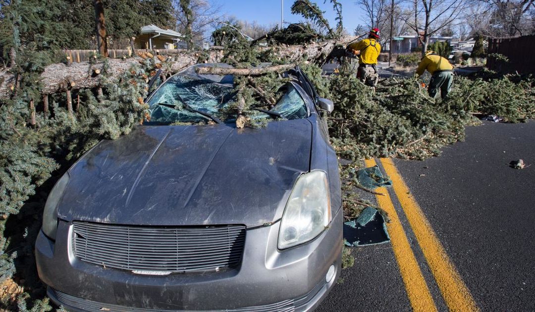
High winds wreaked havoc around Colorado Springs and other areas of the Front Range and Colorado on Wednesday, Dec. 15, 2021.
3:45 p.m.
Colorado College students, faculty and staff are in a shelter-in-place status on campus.
This wind pulled a tree OUT OF THE GROUND at @ColoradoCollege. In my non expert opinion the damage from todays storm is gonna be PRETTY BIG. 😬💨@KKTV11News pic.twitter.com/bQlJZQBP1e
— Nicole Heins (@NicoleHeinsTV)
3:30 p.m.
National Weather Service in Pueblo meteorologist Paul Steward said in an interview that the worst of the wind has passed. The high wind activity was caused by a “pretty intense low pressure system with a “tight gradient of surface pressure differences,” which he said was essentially a “change in pressure over a short distance.” Gusts reached a high of 93 miles per hour, he said, and were amplified by the snow squall that also moved through the Colorado Springs area on Wednesday, he said.
2:36 p.m.
City officials postponed a joint public meeting covering the ConnectCOS and Platte Avenue Corridor study projects in response to internet outages throughout the city, they announced in a Tweet.
Dorcie Childs surveys the damage to his neighborhood in Colorado Springs after wind gust more than 100 mph hit the Pikes Peak Region Wednesday, Dec. 15, 2021. Childs said he had never seen a storm this bad in the 50 years he has lived in his home. (The Gazette, Christian Murdock)
2:15 p.m.
All Colorado Springs School District 11 schools and buildings are on a SECURE status until further notice, according to a D-11 email. This means all students and staff members need to stay inside their building, lock outside doors, and conduct instruction as usual until dismissal. Families may choose to pick up their children early, D-11 said.
2:01 p.m.
The Chapel Hills Mall was evacuated after a “large gas line break,” the Colorado Springs Fire Department tweeted. Firefighters are on scene.
1:56 p.m.
Academy School District 20 officials announced the district cancelled its bus service for Wednesday afternoon “due to high winds and unsafe travel conditions.” They asked families of students who usually take the bus to arrange a way for their students to get home, and said each school will have supervision in place until all students are picked up. Air Academy High School and Douglass Valley Elementary School both released students among power outages.
A large limb lays in the street by the side of the road on N. Tejon St. on Wednesday, Dec. 15, 2021. (Photo by Jerilee Bennett, The Gazette)
1:37 p.m.
Colorado Springs Police Department switched into priority dispatching around noon, meaning officers will only respond to high-risk incidents. Police were also on accident alert as of 7:28 a.m. meaning drivers should only call police for car accidents if there are injuries, drivers suspected to be under the influence or if there is damage to public property. Otherwise, if drivers have all proper documentation, they can fill out a online form to report the accident.
1:20 p.m.
El Paso County issued a shelter-in-place order for all semis, tractor trailers, buses, recreational vehicles and high profile vehicles. These vehicles are not allowed on roadways.
#coloradosprings looks like #phx during a #haboob. Taken from the fifth floor of Plaza of the Rockies. pic.twitter.com/heUv4ODqYe
— Mary Shinn (@maryshinn)
12:46 p.m.
Utilities warned residents not to touch downed wires or anything they are touching and to wait for emergency personnel.
12:42 p.m.
Winds are causing power outages across Colorado Springs due to fallen tree limbs. Around 20,000 Colorado Springs Utilities customers are affected. Outages could be “prolonged” because crews can’t go up in buckets in sustained winds above 35 mph, according to Colorado Springs Utilities.
We currently have about 20,000 customers impacted by electric outages. **Please call us only if it’s an emergency – to report outages use our map on https://t.co/1g4VroTyBc. You can also find it here: https://t.co/4aNP5HuIa2. Crews are mobilizing to respond as conditions allow. pic.twitter.com/jR3mhQ6Jsz
— Colorado Springs Utilities (@CSUtilities)
12:33 p.m.
Traffic lights are out on Union Boulevard between E. Boulder Street and Fillmore Street. Treat intersections as four-way stops.
12:26 p.m.
Woodland Park School District will release classes at 1:30 p.m. due to power issues, the district tweeted.
12:07 p.m.
A high wind restriction has been put in place for CO 115 from 2 miles north of Florence all the way to St. Elmo Avenue in Colorado Springs. Vehicles that weigh, or have less than 10,000 lbs of cargo weight, and are taller than 13 feet 6 inches may be stopped.
12:02 p.m.
More overturned trucks: One has been reported at the northbound entrance ramp from Academy Boulevard to I-25 and another being reported by Colorado State Patrol near Briargate.
11:56 a.m.
Southbound I-25 has been closed to commercial vehicles at County Line Road (Exit 163) due to the high winds, according to the Colorado State Patrol.
11:50 a.m.
U.S. 50 is closed between County Road 25 and County Road 9 (mile markers 378-436) because of the extreme wind. Also, CO 93 is closed between CO 170 and Indian Head Road.
11:34 a.m.
A gust of wind at the U.S. Air Force Academy hit 100 mph.
11:33 a.m.
A brush fire sparked in the 36000 block of Bush Road in eastern Pueblo County, Gazette news partner KKTV reported. Fire danger is expected to be extremely high with red flag warnings in place until 5 p.m., the weather service said.
11:17 a.m.
Interstate 25 closed southbound traffic for commercial vehicles at mile marker 163 at Monument Hill. Winds blew a semi trailer onto it’s side on southbound I-25 near Baptist Road. UPDATE: The semi has been moved to the side of the highway and all lanes are now open.
Southbound Interstate 25 just north of Baptist Rd closed. CDOT working on moving trailer to open at least one lane. Detour Highway 105 pic.twitter.com/3GMKsxipTg
— CSP Colorado Springs (@CSP_CSprings)
10:54 a.m.
A wind gust at the U.S. Air Force Academy hit 91 mph and blew down a stop light near the city’s north end.
Hey Colorado Springs friends – the wind has knocked out the stop lights at Fillmore and Templeton Gap. Treat it like a 4-way stop and be safe. #cows @csgazette pic.twitter.com/2JRciW6TCO
— Matt Wiley (@MWCoyote)
10:00 a.m.
High winds are slamming parts of southeastern Colorado with some gusts reaching 107 mph, according to the National Weather Service in Pueblo.
Winds are sweeping the plains and the agency reported a 107 mph gust in Lamar and snow squalls were reported in Colorado Springs along Interstate 25 and Woodland Park along US-24.
Around 8:42 a.m. and “a wall of dust” headed through Pueblo, the agency said.
WOW! Viewer Paul Banta took this video from the Air Force Academy pull-off looking north during the earlier snow squall warning! The warning was for northern El Paso County and expired at 9:15 a.m.
Send us your weather photos: https://t.co/kBIySUYPKp pic.twitter.com/BLCQ5mHu5E
— KKTV 11 News (@KKTV11News)
A dust storm warning is in effect for La Junta, Las Animas and Rocky Ford until 10:30 a.m. the weather service said.
Gusts in southern El Paso and Pueblo Counties hit 80 mph along I-25 and winds are expected to start increasing along the interstate between 9:30 a.m. and noon with gusts expected to hit 90 mph throughout the Pikes Peak region, the agency said.
842 AM
107 mph gust just occurred at Lamar, across the eastern plains! Very dangerous conditions occurring across far eastern CO at this time. Please use extreme caution! #cowx
— NWS Pueblo (@NWSPueblo)
The weather service warned that winds could blow down trees, power lines and kick up dust, making for hazardous air quality until 8 p.m. Wednesday.
More large plumes of dust blowing around #coloradosprings #cowx pic.twitter.com/5iMSM5snWd
— Matt Minnillo and Blue Thunder (@MattBlueThunder)
US 287 between Springfield and Wiley in eastern Colorado shut down due to fallen power lines and crashes, according to Colorado State Patrol.
Several flights were canceled out of Colorado Springs Airport with many more delayed. Travelers can view the full list of flight cancellations here.
Wednesday’s wind also means fire danger is high because flames could spread at extremely fast and because humidity will also be as low as 14%, the weather service said.
A snow squall warning is in effect until 9:15 AM MST for I-25, US-24 near Colorado Springs, CO and US-24 near Woodland Park, CO. pic.twitter.com/k9IuqaGm5v
— NWS Pueblo (@NWSPueblo)
The rest of the week is forecast to have high temperatures in the 40s with sunny skies, the agency said.
Tuesday marked the 217th straight day without measurable snowfall in Colorado Springs, a streak that has been going since May 11. The longest stretch without snow in Colorado Springs lasted 236 days in 2012 and 1946, according the weather service.
Colorado Springs broke the record for latest measurable snowfall after Dec. 2 came and went without any snow.
Here’s the rest of this week’s forecast from the National Weather Service.
Thursday: Sunny, with a high near 47 degrees and winds between 10 to 15 mph.
Friday: Sunny, with a high near 41 degrees and winds between 5 to 10 mph.
Saturday: Sunny, with a high near 44 degrees and winds between 5 to 10 mph.
Sunday: Sunny, with a high near 56 degrees and winds around 10 mph.
This content was originally published here.